


.
livello elementare
.
ARGOMENTO: MATERIALI
PERIODO: XXI SECOLO
AREA: SUBACQUEA
parole chiave: underwater tablet, navigatori
,
Abstract
Data Collection is one of the main activities for scientific divers and it is usually a painstaking job requiring to write on a slate while wearing bulky scuba gloves and then reading, and try to understand, what you have written and finally insert the information in some sort of computer-based application. This requires time both during the dive and after; moreover interpretation mistakes are always possible mostly during the transfer of the data from the slate to another support. Another “old beast” of scientific divers is to know their precise location while underwater so to geo-correlate the collected data. In many situations failing to precisely locate the proper spatial location of the collected information make them useless. So far the only available method was to use a compass thrusting the dead reckoning ability of the diver. All this could be part of the past thanks to an innovative device that couples the functionality of electronic computer forms with the accuracy of GPS navigation. It is the new Alltab which has been recently presented at DEMA 2017 hosted in Orlando (FL) in November 2017.
 Riassunto
La raccolta dei dati è una delle attività principali per i subacquei scientifici ed è di solito un lavoro scrupoloso che richiede di scrivere su una lavagna portatile subacquea, indossando guanti ingombranti in maniera tale da essere in grado in un secondo tempo di leggere e capire ciò che si è scritto per poi inserire i dati raccolti in un’applicazione o su computer. Ciò richiede tempo, sia durante l’immersione che nella fase seguente fuori dell’acqua; inoltre possono verificarsi degli errori di interpretazione durante il trasferimento dei dati dalla lavagna ad un altro supporto. Un’altra “vecchia bestia” dei subacquei scientifici è quella di conoscere la loro posizione precisa sott’acqua in modo da correlare geograficamente i dati raccolti. In molte situazioni non riuscire a localizzare con precisione la corretta posizione spaziale delle informazioni raccolte li rende inutili. Finora l’unico metodo disponibile era quello di usare la vecchia cara bussola per cercare di geo-referenziare la grande quantità dei dati raccolti con triangolazioni sia in superficie che sott’acqua. Procedura non complessa tutt’altro che facile quando la precisione della raccolta dei dati era essenziale per il ricercatore scientifico subacqueo.Tutto ciò potrebbe far parte del passato grazie a un dispositivo innovativo che abbina la funzionalità delle forme di computer elettronici all’accuratezza della navigazione GPS. È il nuovo Alltab che è stato presentato di recente a DEMA 2017, ospitato a Orlando (Florida) nel novembre 2017.
Alcune caratteristiche:
Profondità operativa: 0-150 m (versione Mil PRO), 0-90 m (versione TechRec)
Tablet: Samsung Galaxy Tab S2 8 “(incluso)
Dimensioni e peso: 264 × 175 × 21 mm, 1425 g. Costruzione robusta, ma leggera e maneggevole
La confezione include: Alltab con tablet all’interno, custodia resistente all’acqua, carica batteria – software di raccolta dati Allure, Valtamer Navigator (per clienti MIL e PRO)

Alltab – una soluzione per professionisti
The Alltab Device
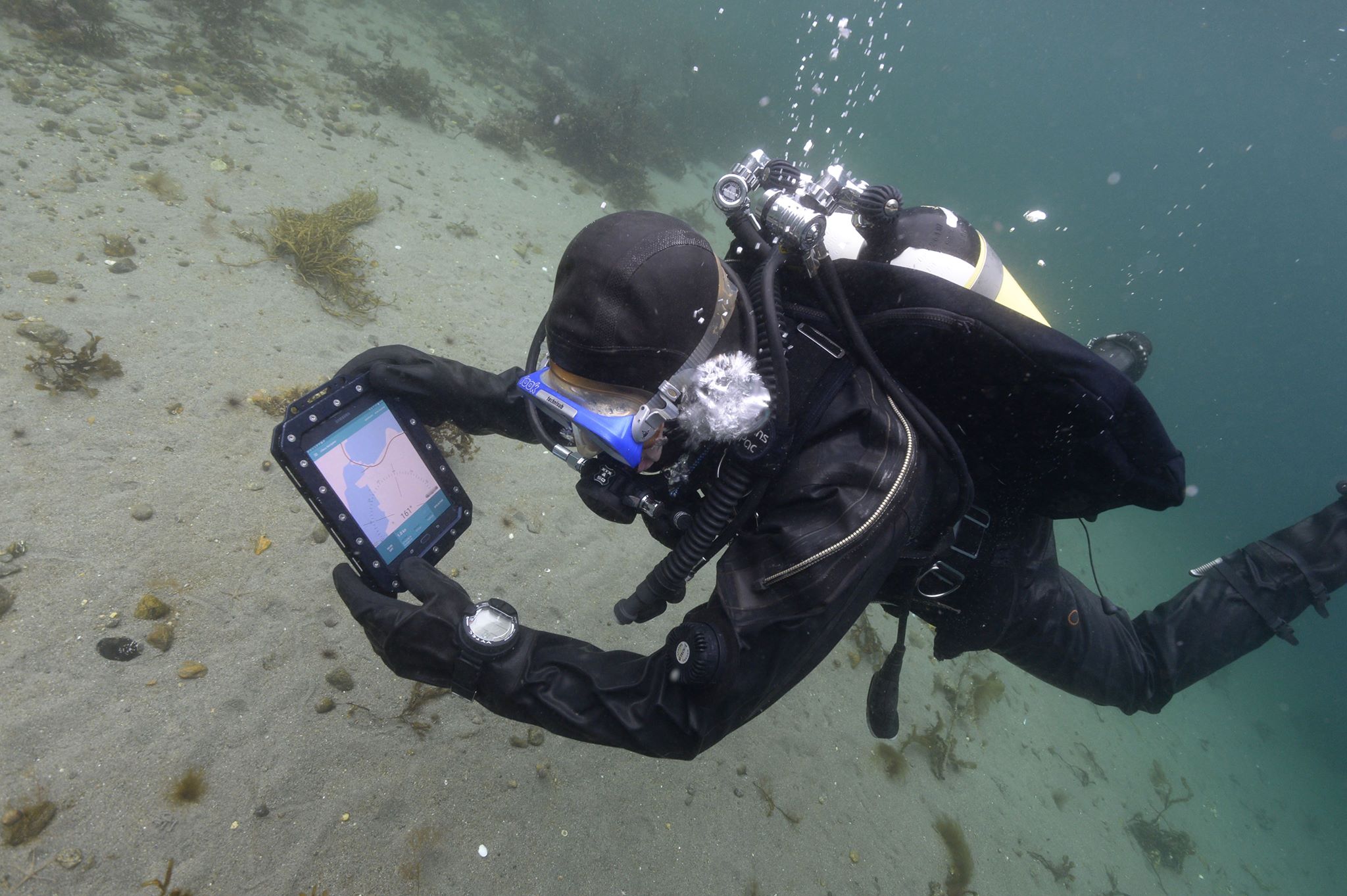
The core of the Alltab is a Samsung Galaxy tab S2 with a 8” screen encased in a tough waterproof shell. The tablet has a fully functional touchscreen that can be used underwater down to a maximum depth of 150 meters (490 ft). A “lighter version” can be used down to 90 meters (295ft). The casing is sealed and does not require to be opened for any operation including the recharging of the tablet that happens through an induction system. This feature strongly reduces the risk of leakage. The scientific applications of Alltab include electronic data collection (also georeferenced), navigational features and the possibility of connecting and controlling other devices. For the data collection a specific software (Allure) has been developed. It is a web-based SaaS that works on any internet browser. One can design e-forms and synchronize them with any desktop or mobile device with an internet access. The forms work also offline, so that one can collect data even without internet connection; the data are then send to a cloud or a local server once the internet connection is available. For a research project this provides a big advantage and it is time saving, because data are immediately available for all research team members with access credentials.
The navigation software “Valtamer Navigator” has offline background maps and a user interface especially developed for underwater use. One can add and name waypoints, mark locations while diving, and also import pre-defined coordinate points and export the waypoints marked while diving. This simplify the data georeferencing, allowing a clear and univocal geographic position of the collected information. The tablet is also able to control a variety of external devices including video and acoustic systems and also more specific scientific instruments such as a coral metabolism measurement device specifically developed at the University of North Carolina, Wilmington by Alina Szmant and her team. The Alltab therefore can be used as a central hub to manage and collect data from several scientific monitoring systems. For the underwater positioning the Alltab accepts a short-baseline acoustic system “Aquametre D-100 NG”. The system is based on the geometric triangulation of multiple acoustic transmitters and it is designed to accurately defining the position of the diver within a 3-D spherical volume of about 400 meters of diameter.
Another navigational feature of the tablet is the possibility of using a GPS device, with a floating wired antenna, called “Allhub”. In an extended version of the system a mobile phone can be connected to the antenna allowing for full-speed mobile internet connection and positioning capabilities based on the Android smartphone system. Last but not least the Alltab works with any Android application and has Wi-Fi and Bluetooth connectivity.

Applications
Being myself a scientific diver, I am extremely interested in the potential applications of an underwater system able to both store data and provide accurate navigation. As example it could be possible to define a grid of sampling points and then swim along a pre-planned path guided by the GPS accurately collecting the needed information filling a customized electronic form that can be then immediately shared online with other researchers. In complex multi-operators projects this would be a great time-saving procedure; moreover the data will be safe in a remote storage so that even if the tablet fails the collected information will be still available.

The mobile telephone connectivity is also a great safety feature allowing divers to be in touch with the surface team exchanging text messages through the dive. This is also a powerful tool during training sessions where one instructor can monitor and exchange even complex information with multiple students using written messages or other visual aids such as pictures and pictograms. The Alltab is definitely a powerful tool that can be used in a variety of situations providing a reliable support for any diver involved in data collection and accurate navigation.
Giorgio Caramanna
.
Alcune delle foto presenti in questo blog possono essere state prese dal web, citandone ove possibile gli autori e/o le fonti. Se qualcuno desiderasse specificarne l’autore o rimuoverle, può scrivere a infoocean4future@gmail.com e provvederemo immediatamente alla correzione dell’articolo
,
PAGINA PRINCIPALE

- autore
- ultimi articoli

geologo (PhD) ed oceanografo, ha fondato la società di consulenza GeoAqua nel 2015 anche al fine di condividere la sua esperienza di ricercatore e subacqueo scientifico, sensibilizzando l’opinione pubblica sui principali problemi ambientali. In possesso di una notevole esperienza in idrogeologia e geochimica ed oltre quindici anni di esperienza come subacqueo scientifico in una varietà di ambienti ha condotto diverse attività di ricerca ed è sttao delegato del gruppo europeo di immersioni scientifiche. Ha lavorato come ricercatore presso molte istituzioni internazionali operando in ambienti multidisciplinari con diverse università. È autore di più di cinquanta articoli ed è revisore di riviste internazionali. Attualmente lavora negli Stati Uniti collaborando come consulente al Woods Hole Oceanographic Institution. Nel 2018 ha ricevuto il Tridente d’oro dell’Accademia Internazionale di Scienze e Tecniche subacquee. Non ultimo è main reporter di OCEAN4FUTURE dagli Stati Uniti


")


Lascia un commento
Devi essere connesso per inviare un commento.